
There we were,
finally on the boat. I thought the boat was rather small, expecting something larger with side decks you could walk around on, maybe
something like this. Instead, there was the inside and the outside - cabin and back deck.

So, what do you do on the boat once you get there? Well, for one thing, you hightail it away from shore, generally keeping the sea-cliff at Deep Creek in your sights behind you for a very long time, as it gets smaller and smaller, and harder and harder to see.

You can sit inside the cabin, pondering this sign posted on the oh-so-tiny bathroom (which has just enough room to stand in while the boat goes back and forth, up and down).

And while inside, you can watch the spray from the rolling waves splash against the cabin windows.

And you can peak out the cabin door, standing up while watching the waves, the wake, and the spray.

If you are quite brave, you can actually stand on the deck, but not too far back, never away from the cabin door, and always holding onto something. I found that location to be disconcerting and mostly just wedged myself inside the door, while MOH ventured out onto the deck. The parental types, more familiar with this boat-ocean thing, sat inside the cabin the whole time.
We were in the water at 9:10 AKDT, and about a half hour later, we could no longer see the details of the coastline behind us, as we still hightailed it farther and farther out.

Birds, mostly gulls, came to follow the wake in anticipation of all the fish we were going to catch.

I'd tell you the names of the mountains, but I
never figured out exactly where we were. Some of the mountains in these photos, the ones to the west of us, might be the Kenai Mountains down near Homer. I don't think we got as far south as Kodiak Island (in less than 1.5 hours!), and we never saw Augustine Volcano, which was probably to the south or southwest.

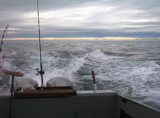
Flotsam and jetsam, which the gulls were immensely interested in, appeared now and then, and the lighting beneath the clouds and on the water was beautiful. The sea was rolling with large waves. My parents weren't impressed, but the captain said it was pretty bad. Maybe he said that to try to make us feel better. I tried to get pictures showing the height of the waves, but you can't really see it, nothing out there for scale, I guess. Perhaps if I hadn't rotated most of these photos so the horizon was horizontal; when I took them, I couldn't hold the camera steady relative to the horizon, only relative to the boat, so the horizon was moderately to highly tilted in most original photos.

Finally, at about 10:20 AKDT, more than one hour out, we started making the turn to set the anchor, so we could begin our fishing.

 There we were, finally on the boat. I thought the boat was rather small, expecting something larger with side decks you could walk around on, maybe something like this. Instead, there was the inside and the outside - cabin and back deck.
 So, what do you do on the boat once you get there? Well, for one thing, you hightail it away from shore, generally keeping the sea-cliff at Deep Creek in your sights behind you for a very long time, as it gets smaller and smaller, and harder and harder to see.
 You can sit inside the cabin, pondering this sign posted on the oh-so-tiny bathroom (which has just enough room to stand in while the boat goes back and forth, up and down).
 And while inside, you can watch the spray from the rolling waves splash against the cabin windows.
 And you can peak out the cabin door, standing up while watching the waves, the wake, and the spray.
 If you are quite brave, you can actually stand on the deck, but not too far back, never away from the cabin door, and always holding onto something. I found that location to be disconcerting and mostly just wedged myself inside the door, while MOH ventured out onto the deck. The parental types, more familiar with this boat-ocean thing, sat inside the cabin the whole time.
 We were in the water at 9:10 AKDT, and about a half hour later, we could no longer see the details of the coastline behind us, as we still hightailed it farther and farther out.
 Birds, mostly gulls, came to follow the wake in anticipation of all the fish we were going to catch.
 I'd tell you the names of the mountains, but I never figured out exactly where we were. Some of the mountains in these photos, the ones to the west of us, might be the Kenai Mountains down near Homer. I don't think we got as far south as Kodiak Island (in less than 1.5 hours!), and we never saw Augustine Volcano, which was probably to the south or southwest.
 Flotsam and jetsam, which the gulls were immensely interested in, appeared now and then, and the lighting beneath the clouds and on the water was beautiful. The sea was rolling with large waves. My parents weren't impressed, but the captain said it was pretty bad. Maybe he said that to try to make us feel better. I tried to get pictures showing the height of the waves, but you can't really see it, nothing out there for scale, I guess. Perhaps if I hadn't rotated most of these photos so the horizon was horizontal; when I took them, I couldn't hold the camera steady relative to the horizon, only relative to the boat, so the horizon was moderately to highly tilted in most original photos.
 Finally, at about 10:20 AKDT, more than one hour out, we started making the turn to set the anchor, so we could begin our fishing.
2 comments:
Out of Ninilchik, the Kenai Mts would be to the east of you. You were looking at the Alaska Peninsula to the west. Most of them don't really have names! They're triassic accretionary complex +/- accreted terrains, locally host to the modern aleutian arc.
Christie, thanks for the info, and knowledge that we were seeing the Alaska Peninsula to the west. I usually coudn't see much in that direction, which surprised me.
It was kind of strange leaving a known locality, heading in apparently one direction the entire time, and not seeing anything recognizable. My dad and I were both trying to keep track of the topography, to no avail; he is also a geologist, and he lives there and is familiar with landmarks - and like you said, there just weren't any!
Alaska is almost entirely a bunch of accreted terranes, isn't it - just like California, except many more, and ongoing.
Post a Comment