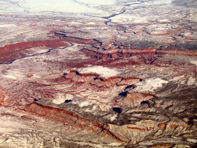
Once again, the unknown area, shown in two photos below, is somewhere in the western part of the United States. Where could it be? Why are some of the rocks so red (besides a slight bit of color enhancement to cancel out the haze)? What is the white unit? What is the basic geology of the area, what are some of the major rock formations, or what is the area known for? Damn, it looks like a river runs through it!

Photo One

Photo Two
The two photos were taken from an unknown altitude, looking northward, almost exactly two years ago. They could almost form stereo pairs, but don't. This is one of my favorite places in the entire world. (Uh, oh! Did I give it away?)
Btw, if you had to pick one geologic time period for the area, what would you pick?
This post, and others, were submitted to the first Carnival of the Arid at Coyote Crossing.
8 comments:
Ah, Professor and Castle valleys in southern Utah. A wonderful spot with a good showing of Triassic-Jurassic rocks, mostly deposited as dunes but also with some intervening wetter periods. Out of one unit, rumor has it, came material used by the Curies. There is a wonderful hike up the small stream, called Mary Jane Creek, in Professor Valley, which extends up to the La Sals, a laccolith, or what is also known as a hot hump between the sheets. There is also a famous spire between the valleys where Bon Jovi shot a video.
Great photos.
Sure looks like the Chinle Fm.
Just off the top of my head, I would guess Triassic age- our strat and sed prof just pounded the phrase "Triassic redbeds" into our brains. It definitely looks like Colorado Plateau landscape, so that fits with the two previous comments.
Yes, David! Professor Valley is in the central part of the first photo, with the Colorado River running along the east side, and Castle Valley is in the foreground, a northwest-southeast-elongate valley running in the same orientation as the nearby Arches anticline, and probably a continuation of the same structure.
There is a fair amount, as you said, of Triassic-Jurassic rock formations. The central part of Professor Valley is underlain by the Permian Cutler Formation. In the distance to the north, the Cretaceous comes into view.
I think the spire in the Bon Jovi video is called Castle Rock, and on occasion in the video - or at least once - you can see Fisher Towers in the background. Fisher Towers don't stand out in my aerial views but kind of blend into the cliffs.
Did the Curies actually get material from this particular area? The Chinle Formation, outcropping beneath a capping sandstone on the west side of Professor Valley, is known for its uranium deposits.
Eddie, the Triassic Chinle Formation is definitely in the picture!
And Lockwood, in this case the redbeds fall into the Permo-Triassic category, because of the Cutler Formation in the bottom of the valley. Most/all of the other red units are Triassic.
Silver Fox,
Yes, that nice Mr. Jovi's video was shot on Castle Rock, or Castleton, as it is also called. I was there during the shooting and I have great memory of an outhouse flying through the air up to the tower. I have spent a great deal of time in the area; it is perhaps my favorite piece of private property in the world. If others are interested in more about that part of the Colorado Plateau, I will make a small plug for a book I wrote about the area called A Naturalist's Guide to Canyon Country, which covers geology, plants, and animals of the area. More info is available at my web site: www.storiesinstone.info
I forget the exact story about the Curies but supposedly they did get uranium from a small mine in the Chinle at the base of one of the cliffs in the valley.
The spire is probably Castleton Tower. There are a couple of uber-classic climbing routes to the top. Here's a link to a panorama I took from the summit (I stitched the 10 images together using a free program called Hugin')
http://picasaweb.google.com/lh/photo/lG7YFDc5LAv7pT0a6os7vg?authkey=9VwYzw5x-kc&feat=directlink
Download the pic for full resolution!
Perry, thanks for the link to the great Panorama.
David, great info! From the video, it looks like a lot of the shooting was from the mesa next to Castle Rock? Maybe that's an appearance due to all the overlapping images.
Anyway, see next post!
Post a Comment