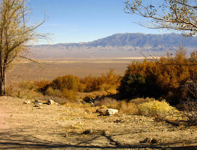
 As long as you happen to be at Ophir Creek in Big Smoky Valley, you should make sure to notice the nice triangular facets along the eastern range front of the Toiyabe Range. The above photo, looking south from the road going up the Ophir Creek alluvial fan, shows the overall faceted nature of the range front near the canyons cut by North Twin River and South Twin River.
 Photo from the road to Ophir Creek, looking southwest, the canyons in view having been cut by South Twin River (the southernmost canyon barely in the far left of the photo), North Twin River (the next large canyon to the north), with the canyons of Hercules Creek and Last Chance Creek just barely seen north of North Twin River.
Triangular facets - a geomorphologic feature or landform - sometimes result from erosion along an active to fairly active fault. Triangular facets can result from other processes, but here in the Basin and Range country of central Nevada, they are almost always indicative of the approximate location of the range-front fault. By fairly active, I mean that ranges and valleys in the Basin and Range are moving with respect to each other, and that fault motion has historically produced earthquakes and fault scarps on some of these range-front faults - for example at Fairview Peak and Dixie Valley. Most range-front faults have not had historic earthquake activity, but many have been active sometime during the last 1.6 million years (Quaternary). On the Google Earth image below, the Toiyabe Range fault zone - the range-front fault on the east side of the Toiyabe Range - is shown as being Late Quaternary, or younger than 130,000 years old.
UPDATE 28May2010: These geomorphic features are also commonly known as faceted spurs. Nice triangular facets on the range front south of Ophir Creek and north of Hercules Creek.
 As the road goes farther up the alluvial fan and gets closer to the mouth of Ophir Canyon, our view of the range front is more southward, and the triangular facets are seen at a more oblique angle.
 Above, an enlargement of the previous photo.
 Another enlargement.
Reference:
U.S. Geological Survey and Nevada Bureau of Mines and Geology, 2006, Quaternary fault and fold database for the United States, accessed 10-27-2008, from this USGS web site: http//earthquakes.usgs.gov/regional/qfaults/.
Historic are the most recent, known movement less than about 150 years (in red).
Holocene_LatestPleistocene are younger than 15,000 years (in orange).
LateQuaternary are younger than 130,000 years (in yellow).
MidToLateQuaternary are younger than 750,000 years (in green).
Quaternary are younger than 1,600,000 years (in blue).


